- Ski.com Home
- Blog
- North America Long-Term Winter Forecast | 70-80% Chance of La Niña
North America Long-Term Winter Forecast | 70-80% Chance of La Niña

Ski season is right around the corner, and what better way to celebrate its coming arrival than unpacking a long-range winter forecast from our friends over at NOAA? This year, there are a few reasons to be optimistic regarding snowfall in the Western USA, and we'll do our best to sufficiently cover the main meteorological trend that is catching our eye: LA NINA!
Related: The Winter 2022 Forecast Indicates Above-Average Snow Totals for These 17 Resorts
A recent NOAA forecast discussion for the upcoming winter states, "it’s looking more probable that La Niña will lock in by this winter." The discussion goes on to explain how forecast models agree that this upcoming season will most likely be a repeat or "second-year La Niña" with chances of colder temperatures and above-average snowfall arriving in the Northern Rockies and Pacific Northwest during the month of October. Those conditions are likely (70-80% chance) to persist through the spring of 2022!
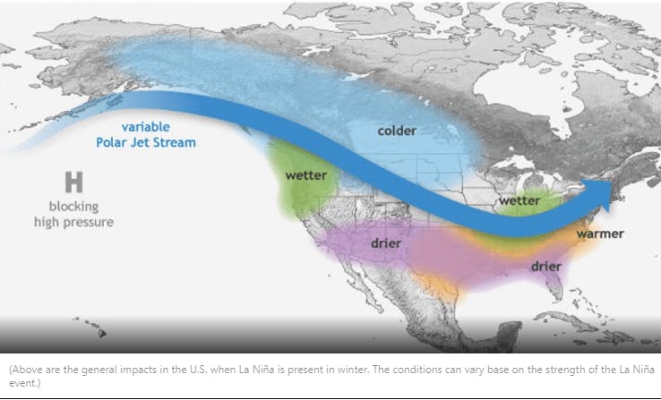
WHAT DOES A LA NIÑA WINTER MEAN?
On a typical La Niña year, the jet stream tends to hold a more northern positioning, which can mean consistent cold storms in places like British Columbia, Oregon, Idaho, Wyoming, Montana, Utah, and central/northern Colorado.
While each La Niña has the potential to be wildly different from the last, the southern states of the Western USA tend to receive slightly less than average snowfall and above-average temperatures. That said, there have been multiple La Niña seasons that have delivered historic snowfall to California, so please take these generalizations lightly.
In terms of the East Coast, the direct effects of La Nina become severely diminished as the jet stream moves from west to east so we'll mostly leave New England out of this conversation. However, the below outlooks from NOAA indicate equal chances for average snowfall for the majority of the northeast with above-average temps forecasted.
WHERE WILL IT SNOW THIS WINTER?
Ask any meteorologist and they'll tell you forecasting accurately beyond 10 days is nearly an impossible task. However, long-range modeling has come a long way in the past decade, and while we don't encourage people to take these forecasts as a guarantee of perfect powder, this outlook can be a helpful tool for those on a quest to find the deep stuff. Here are the three-month temperature and precipitation outlooks for the main winter months (December-February).
NOAA PRECIPITATION OUTLOOK – WINTER 2021-2022
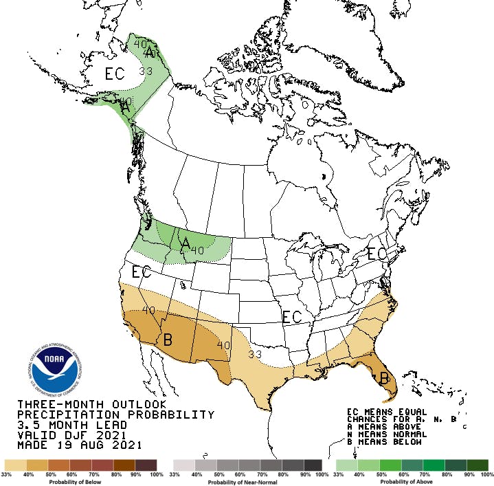
As you can see, this precipitation outlook map is largely in agreement with the current forecast discussion regarding La Niña. Resorts with a more northern positioning will likely see more snowfall and colder temps. This could include ski resorts such as Sun Valley, Big Sky, Mt Bachelor, Whitefish, Schweitzer, and even Alaska's Alyeska Resort.
NOAA TEMPERATURE OUTLOOK – WINTER 2021-2022
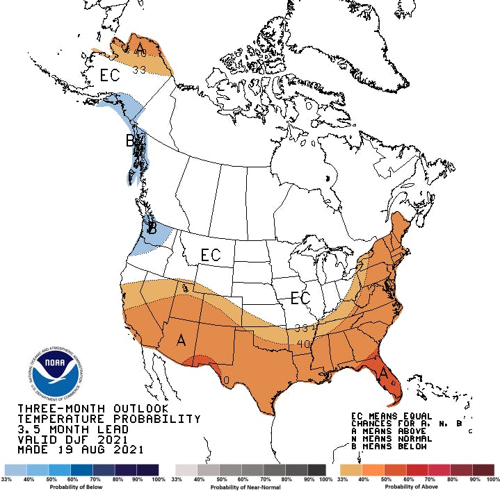
Below average temps are only being forecasted in coastal areas of the Pacific Northwest. Oftentimes, this means low-moisture content snow (light powder) in places that are known for the heavy stuff. Look to places like Whistler Blackcomb and Mt Bachelor to benefit greatly from this temperature trend.
LA NIÑA DISCUSSION | NOAA
A transition from ENSO-neutral to La Niña is favored in the next couple of months, with a 70-80% chance of La Niña during the Northern Hemisphere winter 2021-22.
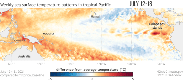
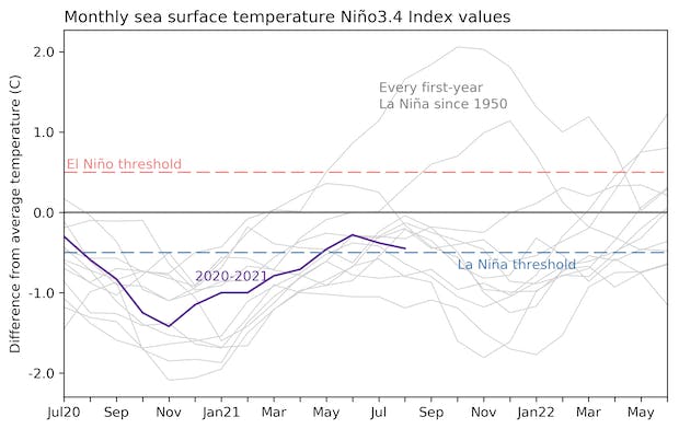
In the last month, ENSO-neutral continued with near-to-below average sea surface temperatures (SSTs) persisting in the central and eastern equatorial Pacific [Fig. 1]. In the last week, all of the Niño index values ranged from -0.2°C to -0.3°C [Fig. 2]. Negative subsurface temperature anomalies (averaged from 180-100°W) remained steady in August [Fig. 3], reflecting below-average temperatures that extended from the surface to ~250m depth in the eastern Pacific Ocean [Fig. 4]. Low-level wind anomalies were easterly over the western Pacific Ocean, while upper-level wind anomalies were westerly over the western and east-central Pacific. Tropical convection was suppressed near and west of the Date Line and enhanced over Indonesia [Fig. 5]. Given these conditions, the ocean-atmosphere system reflected ENSO-neutral but is edging toward La Niña.
The IRI/CPC plume average of forecasts for the Niño-3.4 SST region from the last month favored borderline or weak La Niña during the fall and winter 2021-22 [Fig. 6]. The forecaster consensus this month, however, favors the latest predictions from the NCEP CFSv2 and the North American Multi-Model Ensemble, which suggests higher chances for the emergence of La Niña. At this time, forecasters anticipate La Niña to be of weak strength (seasonal average Niño-3.4 index values between -0.5°C to -0.9°C). In summary, a transition from ENSO-neutral to La Niña is favored in the next couple of months, with a 70-80% chance of La Niña during the Northern Hemisphere winter 2021-22 (click CPC/IRI consensus forecast for the chances in each 3-month period).
WHAT CAUSES EL NIÑO AND LA NIÑA?
Good question. Perhaps one of the more complicated climate interfaces in our natural world, the El Niño Southern Oscillation (ENSO) is responsible for wide-ranging shifts in weather patterns that are caused largely by the heat content and positioning in the Pacific Ocean.
“ENSO is one of the most important climate phenomena on Earth due to its ability to change the global atmospheric circulation, which in turn, influences temperature and precipitation across the globe” – NOAA
Depending on the temperature of the western vs. eastern regions of the equatorial Pacific Ocean, the atmosphere and subsequent meteorological drivers like the Jet Stream can be altered and have far-reaching effects on everything from rice harvests in Indonesia to snow depths in Colorado. On a typical La Niña year, the heat content in the southeastern Pacific is below average, which in turn causes the jet stream to move further north and subsequently, delivers more snow and cold temperatures to the upper half of the Western United States.
Also Read: How To Plan a Last-Minute Powder Chase
Are you eager to get on the slopes for the 2021-2022 ski season? Get matched with one of Ski.com’s 65+ Mountain Travel Experts and receive a free quote today. Nobody understands why you crave time in the mountains more than we do, and nobody knows how to guide you there better.
Barclay Idsal
Author
Latest blogs
View All


How Our Free White (Ski) Glove Service Works:

Reach out to a Ski.com Mountain Travel Expert by phone, chat, or our online form. Share details about your group size, interests, and budget and your Expert will begin to craft your dream ski vacation.
Get a curated proposal with personalized suggestions from your Expert via email. Book directly online or request additions or revisions from your Expert until it’s perfect.
If you have questions, want to add or modify your reservations or need anything assistance, your Expert is always by your side to help before, during and after your trip.
Sign up for our newsletter
Sign up for exclusive offers, news, updates and more.